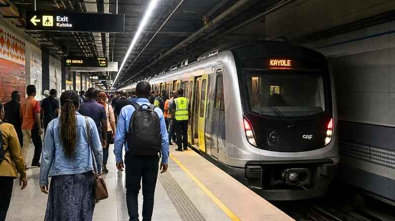

Nairobi’s planned metro railway will not remain underground throughout the capital, with new project details showing how trains are expected to emerge from beneath the city centre before continuing towards Eastlands on elevated and surface tracks.
The proposed Nairobi Metropolitan Mass Rapid Transit System (NMRTS) will use three different railway configurations depending on the part of Nairobi being served.
Trains will run underground through the central business district before gradually rising above ground around Muthurwa. The railway will then continue on elevated infrastructure towards Eastlands, before sections farther from the city centre return to ground level.
The approach means Nairobi’s future metro could combine underground tunnels, elevated viaducts and conventional surface railway within the same metropolitan network.
For commuters, the design is particularly significant because Muthurwa is expected to become a major interchange connecting the metro with other forms of public transport.
Explore the Nairobi Metro Lines & Underground Railway Guide
Nairobi CBD to Get Underground Metro Section
At the centre of the proposed system is an underground railway beneath Nairobi CBD.
Plans provide for a 10-kilometre twin-bore underground section serving 10 stations, allowing trains to move beneath the city instead of competing with vehicles for space on Nairobi’s already congested roads.
One of the most important stations would be Kencom Central Station, planned beneath the City Hall Way area.
The station would sit approximately 12 to 16 metres underground, with a chamber measuring about 20 to 25 metres across. Passengers would reach the underground concourse from street level using lifts and escalators.
This would effectively introduce a new layer to Nairobi’s public transport system: commuters moving below the road network while buses, matatus, pedestrians and ordinary traffic continue operating above.
Explore Nairobi’s Existing Commuter Rail Routes & Stations
Metro Trains Will Emerge Around Muthurwa
The railway’s configuration changes as trains leave central Nairobi.
Instead of continuing underground towards Eastlands, the line is designed to rise gradually through a transition section around Muthurwa.
Tracks would emerge from the tunnel through a portal and climbing section before reaching an elevated railway approximately eight to 12 metres above ground.
From there, trains would continue towards Eastlands above the existing urban environment.
This transition makes Muthurwa particularly important to the overall metro design.
Rather than simply becoming another station, the area would effectively mark the point where Nairobi’s metro changes from a subterranean railway into an elevated urban transit system.
Roads and Other Activity Could Continue Beneath the Railway
Building the railway above ground through parts of Eastlands would allow existing road traffic and other activity to continue beneath the metro infrastructure.
The elevated railway is planned within a corridor approximately 18 to 25 metres wide.
This could be particularly important in densely developed parts of Nairobi where acquiring enough land for an entirely new ground-level railway corridor would be difficult.
Instead, elevated infrastructure allows trains and road traffic to occupy different vertical levels.
For Nairobi commuters, this represents a fundamentally different transport model from the city’s existing commuter railway, where trains largely operate at ground level.
View the Kenya Train Routes, SGR & Commuter Rail Guide
Muthurwa Could Become One of Nairobi’s Biggest Transport Interchanges
Muthurwa’s importance extends beyond the change from underground to elevated railway.
Plans identify the area as a multimodal interchange, where passengers could move between several different forms of transport.
The proposed interchange would bring together:
Electric metro trains
Bus Rapid Transit (BRT)
Conventional buses
Taxis
and:
Walking and other non-motorised transport
Railway platforms would sit above ground while BRT infrastructure, bus bays and pedestrian facilities operate beneath them.
If implemented as planned, Muthurwa could therefore become much more than a railway station.
It could function as a major transfer point between Nairobi’s eastern commuter corridors and the CBD, allowing passengers to change transport modes without every journey having to continue into the centre of town.
Explore Nairobi’s Planned BRT Routes
Why Muthurwa Matters for Nairobi Matatu Commuters
The interchange concept is particularly relevant to Nairobi’s existing public transport system.
Today, a large proportion of commuters entering Nairobi from Eastlands depend on matatus and buses travelling through corridors such as Jogoo Road, Outer Ring Road and surrounding Eastlands routes.
A future metro interchange at Muthurwa could change how some of those journeys work.
Instead of relying exclusively on a matatu for the entire journey into the CBD, passengers could potentially use road-based public transport as a feeder service, transfer to the metro and complete part of the journey by rail.
That makes integration with existing matatu stages, bus routes and pedestrian connections just as important as construction of the railway itself.
View all Nairobi Matatu Routes and Numbers
Explore Nairobi Bus Stations, Matatu Stages & Termini
Railway Will Eventually Return to Ground Level
The elevated railway is not expected to continue indefinitely.
As the network moves farther away from central Nairobi and reaches areas where sufficient railway corridor space is available, trains would return to surface-level tracks.
The plans identify parts of Embakasi, Umoja and Kayole for this type of infrastructure.
Surface sections would occupy a designated corridor approximately 20 metres wide.
Stations in these sections would also be built at ground level.
Dandora is among the locations identified for a surface station.
The project therefore moves through three distinct physical forms:
Nairobi CBD → Underground
Muthurwa/Eastlands → Elevated
Outer residential areas → Ground level
That transition is one of the defining engineering features of the proposed system.
Metro to Use Electric Power
The surface railway sections are planned with overhead electrification.
Power wires would be positioned approximately six to eight metres above the railway tracks, according to the project design.
The plans also provide for pedestrian paths and feeder connections alongside parts of the surface railway.
This is important because the effectiveness of the metro will depend not only on the trains themselves but also on how easily commuters can reach stations from surrounding neighbourhoods.
Eastlands Could See Major Change in How Commuters Reach Nairobi CBD
The Eastlands component could ultimately have some of the biggest consequences for everyday commuting.
Areas such as Umoja, Embakasi, Kayole and Dandora feed large numbers of passengers into Nairobi’s existing matatu and bus network every day.
A high-capacity electric railway running through this part of Nairobi would introduce another option alongside matatus, buses and the existing commuter rail system.
Rather than necessarily replacing road-based public transport, the future system could increasingly make matatus and buses part of a wider feeder network connecting neighbourhoods with metro stations and major interchanges.
Metros already maps many of these connections through its Nairobi public transport database.
Explore the Nairobi Matatu SACCOs, Routes & Destinations Guide
Three Rail Designs for One Nairobi Metro Network
The decision to combine underground, elevated and surface railway infrastructure reflects the different physical environments the metro would encounter across Nairobi.
Dense development in the CBD makes underground construction attractive because railway infrastructure can be separated from streets above.
Around Muthurwa and parts of Eastlands, elevated infrastructure would allow trains to cross developed areas while maintaining activity underneath.
Farther out, where sufficient corridor space can be provided, surface railway becomes possible.
The project master plan therefore does not treat Nairobi as one uniform environment. Instead, the railway configuration changes as the urban landscape changes.
Nairobi’s Future Transport Network Goes Beyond the Metro
The proposed metro is only one part of the broader transformation being planned for Nairobi’s transport system.
The capital already has an existing commuter rail network, while separate plans envisage BRT corridors and expanded public transport interchanges.
Metros is tracking these projects alongside the existing matatu network so commuters can understand how the different systems could eventually connect.
Explore Nairobi Commuter Rail Routes, Stations & Fares
Explore Nairobi BRT Routes & Bus Rapid Transit
Explore the Nairobi Metro Lines & Underground Railway
View all Nairobi Matatu Routes and Numbers
What the Nairobi Metro Design Means for Commuters
The most significant feature of the proposed system may ultimately be integration.
A commuter could eventually move between a neighbourhood matatu, an interchange such as Muthurwa, an electric metro train and another public transport service without every mode attempting to perform the entire journey independently.
Muthurwa illustrates that approach particularly clearly.
Under the current proposal, metro trains would arrive on elevated platforms while BRT vehicles, buses and pedestrian connections operate below.
If delivered as envisioned, Nairobi would therefore be moving towards a layered public transport network in which matatus and buses provide local access, high-capacity rail carries commuters across major corridors, and interchanges connect the different systems together.
For commuters, the transformation would be visible physically: trains travelling beneath Nairobi CBD, rising above the city around Muthurwa and eventually returning to ground level as the network reaches the outer suburbs.