
Nairobi may have thousands of streets, but much of the city’s daily movement depends on a relatively small number of major transport corridors.
Thika Road carries commuters from the northern and northeastern parts of the metropolitan area. Waiyaki Way provides the western gateway. Mombasa Road connects the city with JKIA and the country’s principal highway towards the coast. Ngong Road and Lang’ata Road serve rapidly growing residential areas to the southwest, while Jogoo Road and Outering Road carry enormous volumes of movement through Nairobi’s eastern neighbourhoods.
Then there are the bypasses, the Nairobi Expressway and dozens of connecting roads that allow motorists and public transport vehicles to move between these corridors without necessarily passing through the CBD.
For commuters, understanding these roads can make Nairobi’s transport network much easier to understand.
It also explains why a crash, flooding, roadworks or traffic disruption on one road can quickly affect journeys several kilometres away.
Nairobi’s road network works like a series of corridors
Think of Nairobi as a transport network rather than a collection of individual roads.
The CBD remains an important centre, but commuters increasingly travel between residential, commercial and industrial areas without entering central Nairobi.
Major roads therefore perform different functions.
Some bring commuters towards the city centre.
Others move traffic around it.
Some connect Nairobi with neighbouring counties, while others have become major public transport corridors carrying dozens of matatu routes.
This road network works alongside the city’s extensive matatu system. Metros Kenya’s Nairobi Matatu Routes and Numbers database provides a wider guide to the route numbers and destinations operating across the capital.
Here are the corridors that matter most.
Thika Road: Nairobi’s northern super-corridor
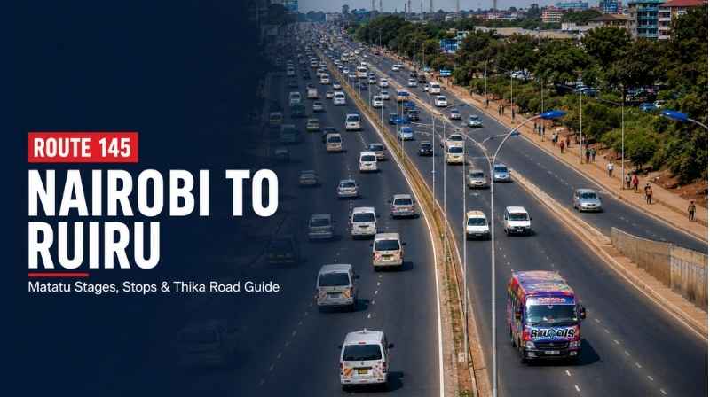
Thika Road — officially part of the A2 — is one of Nairobi’s most important commuter arteries.
The highway runs northeast from Nairobi towards Thika and carries traffic serving areas including Pangani, Muthaiga, Kasarani, Roysambu, Githurai, Ruiru and Juja.
Its importance goes far beyond private cars.
Large numbers of matatus and buses use the corridor every day, making it one of Nairobi’s busiest public transport routes.
For commuters travelling along the highway and surrounding neighbourhoods, Metros has a dedicated Thika Road matatu routes guide covering services operating along the corridor.
Thika Road also demonstrates how disruption on one major highway can spread.
When traffic builds around Kasarani, Roysambu, Githurai or the approaches to the CBD, surrounding roads can begin absorbing vehicles attempting to escape the congestion.
Waiyaki Way: Nairobi’s western gateway
Heading west from the city is another major commuter corridor: Waiyaki Way.
The road serves Westlands and extends towards Kangemi, Mountain View, Uthiru, Kinoo and Kikuyu, connecting Nairobi with the western side of the metropolitan area.
It is particularly important because it combines several different types of movement.
There are daily commuters travelling between western suburbs and the city, long-distance traffic heading towards western Kenya and significant commercial activity around Westlands and neighbouring areas.
Public transport passengers can consult the Metros Waiyaki Way matatu routes guide when identifying services operating along the corridor.
The Nairobi Expressway has also changed movement along sections of the wider Waiyaki Way–Uhuru Highway–Mombasa Road axis by providing an elevated alternative for qualifying motorists.
Mombasa Road: Nairobi’s connection to JKIA and the coast
Few Nairobi roads have as many different transport roles as Mombasa Road.
It carries daily commuters.
It serves Nairobi’s industrial areas.
It provides access towards Jomo Kenyatta International Airport.
And it forms part of the strategic highway connecting Nairobi towards Athi River and ultimately Mombasa.
That mixture means commuter vehicles, trucks, airport traffic and long-distance vehicles can all share the same wider corridor.
Metros’ Mombasa Road matatu routes guide helps passengers identify public transport services serving destinations along and beyond the corridor.
Mombasa Road is also particularly important to the Nairobi Industrial Area transport network, where thousands of workers travel daily to factories, warehouses and businesses.
Nairobi Expressway: the elevated route across the city
The Nairobi Expressway introduced another layer to the capital’s road network.
Running along the wider Mombasa Road–Uhuru Highway–Waiyaki Way corridor, the expressway allows motorists to bypass a number of junctions and surface-level congestion points.
Its role is different from the traditional matatu corridors because access is controlled and toll-based.
But its impact extends beyond vehicles actually using it.
Movement on the expressway interacts with traffic entering and leaving at interchanges, while the roads underneath continue carrying large volumes of conventional traffic and public transport.
For anyone trying to understand Nairobi’s transport geography, the expressway should therefore be viewed as part of a wider east-west transport spine rather than an isolated road.
Jogoo Road: one of Eastlands’ great commuter arteries
To understand Nairobi public transport, you have to understand Jogoo Road.
The corridor carries commuters between the CBD and some of Nairobi’s densely populated eastern neighbourhoods.
Areas connected directly or indirectly through the corridor include Makadara, Jericho, Hamza, Umoja and surrounding parts of Eastlands.
Matatus are central to that movement.
Metros has mapped the services in its Jogoo Road matatu routes guide, which forms part of the wider Nairobi public transport database.
Jogoo Road also connects with other important roads serving eastern Nairobi, meaning congestion there can affect journeys beyond passengers whose destination is actually located along Jogoo Road.
Outering Road: the road connecting Eastlands
Outering Road performs a different function.
Rather than simply carrying commuters towards the CBD, it provides an important north-south connection across eastern Nairobi.
The corridor links areas around Embakasi with neighbourhoods further north and connects with several other important transport routes.
That makes Outering Road particularly useful for journeys that do not necessarily require travelling through central Nairobi.
Its public transport importance is reflected in the number of routes using or crossing it.
Passengers can explore these services through the Metros Outering Road matatu routes guide.
This is the type of corridor that becomes increasingly important as Nairobi evolves from a city where most journeys lead to the CBD into a metropolitan area with multiple employment and commercial centres.
Ngong Road: the southwest commuter corridor
Ngong Road carries traffic between central Nairobi and neighbourhoods stretching southwest through areas such as Kilimani, Adams Arcade and further towards Ngong.
Residential and commercial development along the corridor has increased its importance considerably.
It is used by private vehicles, matatus, buses, boda bodas, cyclists and pedestrians, making it a particularly diverse transport environment.
Metros’ Ngong Road matatu routes guide provides commuters with the route numbers and destinations served along this part of Nairobi.
Ngong Road also intersects with several important connecting roads, allowing traffic to move towards areas such as Lavington, Kilimani, Karen and the CBD.
Lang’ata Road: the gateway to Lang’ata and Karen
Lang’ata Road is another crucial southwestern corridor.
It carries commuters towards Lang’ata, South C, parts of Karen and neighbouring areas while also providing access to major institutions and attractions.
The road is especially important during peak commuter periods because several residential areas feed traffic towards it.
Public transport passengers can use the Metros Lang’ata Road matatu routes guide to understand the services operating along the corridor.
Lang’ata Road also provides connections towards other roads serving southern Nairobi, making it important for journeys that extend beyond Lang’ata itself.
Kiambu Road: Nairobi’s growing northern commuter route
Kiambu Road has become increasingly important as residential development has expanded north of Nairobi.
The corridor serves neighbourhoods and developments stretching from the city towards Kiambu County.
That means its morning and evening traffic increasingly reflects metropolitan commuting rather than movement entirely within Nairobi County.
Matatus form an important part of that connection, particularly for passengers travelling between Nairobi and residential areas further north.
The Metros Kiambu Road matatu routes guide provides more information about the public transport services using the corridor.
The bypasses are changing how Nairobi moves
Not every major Nairobi road is designed to take commuters towards the CBD.
The bypass network exists partly to move traffic around the city.
The Northern Bypass, Eastern Bypass, Southern Bypass and Western Bypass provide connections between major highways and developing parts of the metropolitan region.
Their importance is particularly clear for freight and cross-city traffic.
A vehicle travelling between two outer parts of Nairobi should not always need to pass through the city centre.
The bypasses provide alternatives.
They have also encouraged residential, commercial and industrial development along previously peripheral areas, gradually changing Nairobi’s transport geography.
Metros has been building individual route coverage around these corridors as part of its wider Nairobi transport database.
One road problem can become a citywide traffic problem
Nairobi’s major roads do not operate independently.
They intersect.
Traffic moves between them.
That means disruption can spread.
An incident on Mombasa Road can affect surrounding industrial roads.
Congestion on Thika Road can spill onto connecting roads.
Problems on Jogoo Road can influence traffic elsewhere in Eastlands.
Flooding can make this effect even more pronounced because motorists begin searching for alternative routes simultaneously.
This is why commuters should consider both traffic and weather when planning journeys.
Metros Kenya’s Nairobi Weather Today and This Week coverage provides forecast information that can be considered alongside transport conditions, particularly during periods of heavy rainfall.
Nairobi’s roads are also its public transport map
Look at Nairobi’s matatu network and something quickly becomes clear.
Many routes are essentially organised around major road corridors.
Thika Road has its group of destinations.
Jogoo Road has another.
Ngong Road, Waiyaki Way, Mombasa Road and Lang’ata Road each support their own network of services before those routes branch into neighbourhoods.
This is why understanding the road often makes understanding the matatu easier.
A commuter who knows which major corridor serves a destination has already solved part of the journey.
From there, the Nairobi Matatu Routes and Numbers guide can help identify the appropriate route number, while the Nairobi Matatu SACCOs, Routes and Destinations directory helps identify operators.
The Nairobi Bus Stations and Matatu Stages guide then helps answer another crucial question:
Where do I board?
Together, the roads, routes, SACCOs and stages form the practical architecture of Nairobi’s public transport system.
Nairobi is becoming a network of journeys, not simply journeys to the CBD
For decades, Nairobi transport could largely be understood as movement into and out of the city centre.
That model is changing.
Westlands is a major employment centre.
Upper Hill attracts thousands of workers.
Industrial Area remains a major employment zone.
Commercial centres have developed along Thika Road, Ngong Road, Mombasa Road and other corridors.
Residential development has also pushed further into neighbouring Kiambu, Machakos and Kajiado counties.
As a result, Nairobi increasingly needs roads that allow people to travel across the metropolitan area, not simply between home and the CBD.
That makes roads such as Outering Road and the bypasses increasingly important.
Understanding Nairobi starts with understanding its roads
For the commuter standing at a matatu stage, Nairobi’s transport system can sometimes look chaotic.
Step back and look at the major corridors, however, and a structure begins to appear.
Thika Road serves the north and northeast.
Waiyaki Way carries the western corridor.
Mombasa Road forms the southeastern gateway.
Jogoo Road anchors major Eastlands movements.
Outering Road connects eastern Nairobi.
Ngong Road and Lang’ata Road carry large parts of the southwest.
The bypasses increasingly connect these corridors without requiring every journey to pass through the CBD.
Those roads form the skeleton.
Matatu routes, SACCOs, bus stages, railway stations, boda bodas and future mass-transit systems sit around it.
And for anyone trying to understand how Nairobi moves, the road beneath the journey is often the best place to start.